-
NASA Kennedy Space Center and MINWR
Portfolio Date April 17, 2015 - Ecosystem and Wildlife Management
- ecolo-gis, Ecosystem and Wildlife Management
- Share This
This project dealt with management of feral hog populations at MINWR and NASA’s Kennedy Space Center (KSC) in Florida, USA. During the Project Dr. Rosenfeld worked closely with MINWR personnel and local hunters to capture, tag and re-capture feral hog on KSC grounds.
More than 100 hogs were trapped. Using program MARK, the population size was estimated and population dynamics were analyzed. Using program RAMAS changes in population over time were estimated, proving the need for management.
Feral hog habitat selection was analyzed using LIDAR data and LANDSAT derived vegetation maps in GIS. The factors that most influenced feral hogs habitat selection were forest density and the distance to citrus groves.
Link to Full Report
Published on NASA’s site
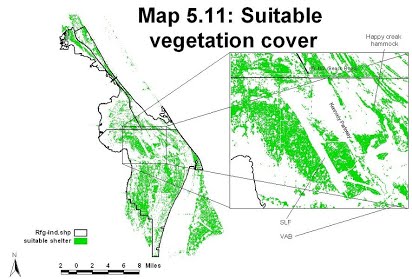
A map of suitable vegetation cover in MINWR. This map was created
using a vegetation map derived from LANDSAT images and vegetation
height covers derived from a KSC LIDAR data set.
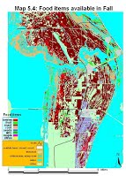
Trapped and tagged feral hogs A map of winter food
sources in KSC